Asia
Glaciers in Asia are known to many as the ‘Third Pole’ due to the fact that high mountains of Asia hold the largest frozen water outside the polar areas. They are an invaluable water resource, feeding many of the world’s great rivers, including the Ganges.
This water resource, however, is a risk under the current trend of global warming. Asian mountain glaciers will lose over one third of their mass by the end of this century as a result of global warming, affecting millions of people who rely on them for fresh water, a study finds.

Sabalan Glacier, Iran – Klaus Thymann (2014)
The glacier region of Sabalan rests on an inactive stratovolcano that rises to a height of 4,811 metres in the north-western part of Iran. The highest peaks of the mountains, known as Mount Sabalan, is a crater lake which is covered with ice from September through to June the next year.
Europe
Many of the glaciers in continental Europe develop on mountain ranges: The Alps, the Great Caucasus range, the Scandinavian mountains, Polar Ural and the Pyrenees. Glaciers on Iceland and Svalbard exist on lower altitudes, and exist due to their proximities to the North Pole.
The vast majority of glaciers in Europe are retreating. Those in the Alps have lost half of their volumes since 1900, with clear acceleration since the 1980s. Glacier retreat in Europe is expected to continue in the future.
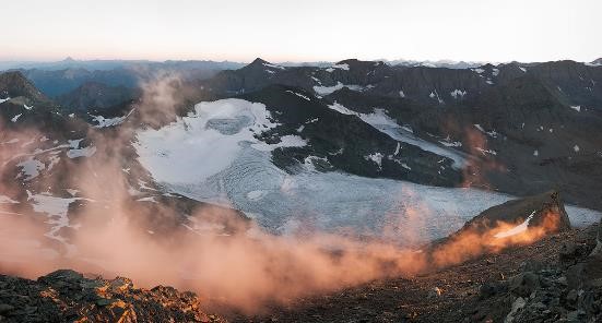
Glacier Du Baoumet, France – Scott Conarroe (2015)
Sunrise shot of Glacier Du Baoumet. In places on the Alps, the borders of Switzerland, Italy, Austria and France are based on watershed. As global warming shrinks the glaciers, so does the watershed shift. The alpine landscapes no longer conform to borders established in the last century.
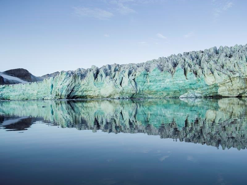
Esmarkbreen, Svalbard – Corey Arnold (2013)
The front of Esmarkbreen, a tidal glacier on the Norwegian archipelago of Svalbard in the Arctic Ocean. The glacier was named Professor Jens Esmark (1763–1839), a Danish-Norwegian pioneer in glacial geology, who was the first to present convincing evidence for a glaciation in northern Europe.
South America
The glaciers in South America develop exclusively on the Andes; many on steep slopes and peaks above elevations of 5,000 metres. One of the most concerned region is the tropical Andes (Venezuela, Colombia, Ecuador, Peru, and Bolivia), where 99% of the world’s tropical glaciers occur. These tropical glaciers are regarded as among the most sensitive indicators of climate change on the planet, according to the Intergovernmental Panel on Climate Change. Being a key aspect of the region’s water cycle, these glaciers have since the 1970s shrunk by 30–50%, an unprecedented rate in the past 300 years.
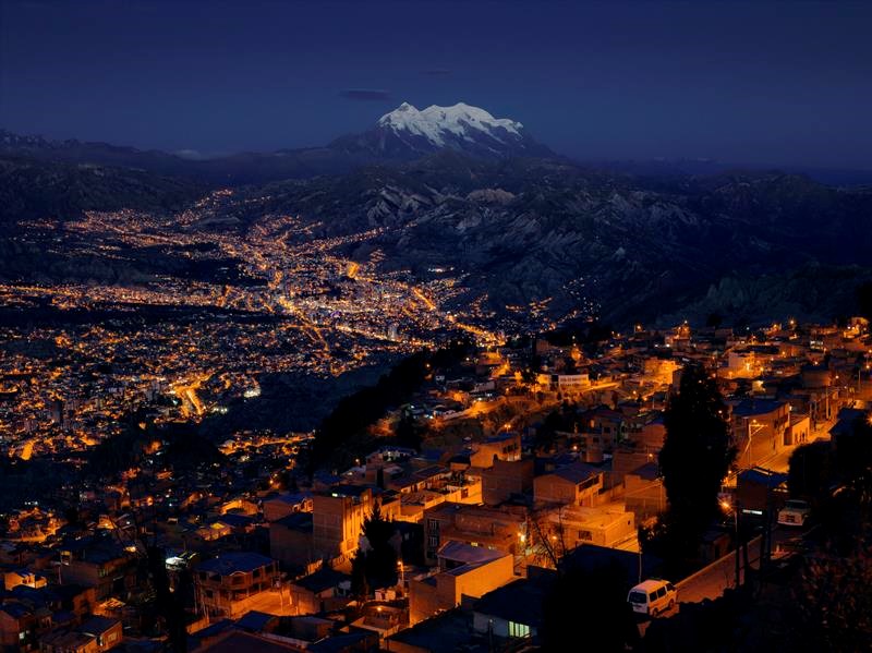
Mount Illimani, Bolivia – Klaus Thymann (2013)
Between the Pacific and the spine of the Andes, which curves through the southwest of the country, lies the vast, arid Andean Plateau. It is home to the city La Paz, and the grasses of the Altiplano Highlands of Bolivia. Further east, the grasslands and dry deserts give way to towering mountains and glaciers, and hidden by the forbidding Andean peaks is the Amazon basin.
Nestled within the Cordillera Real Range is La Paz, the world’s highest capital city at 3,640 metres above sea level. The city with a backdrop of peaks above 5,000 metres, including Mount Illimani, the second highest peak of Bolivia, is sustained by the glacial meltwater runoff. As glaciers recede the landlocked country is losing a vital resource that is not only used for water consumption but also contributes to forestry and agriculture, indigenous communities’ livelihood, and hydroelectric power generation.
North America
Glaciers in North America exist in both the United States and Canada, as well as in Greenland. Many of these glaciers are well monitored and designated as protected areas of National Parks in the United States and Canada. Albeit protected, many of these areas, if not all, are still affected by climate change. One of such areas are Mount Baker-Snoqualmie National Forest in the United States.
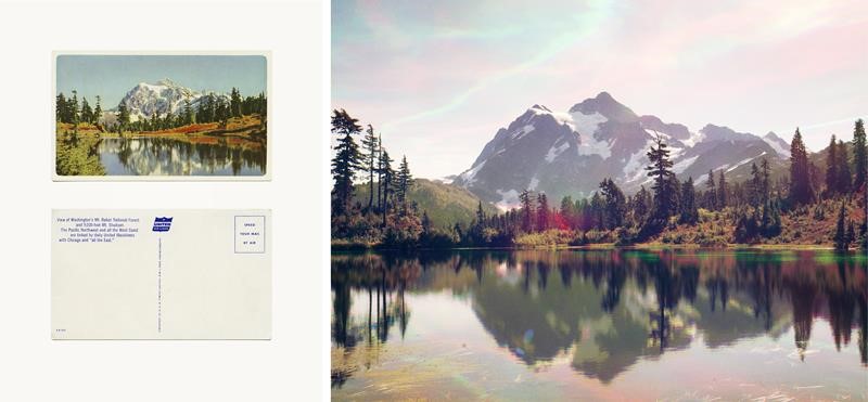
Mount Baker, USA – Peter Funch (2014)
Mount Baker, located in Washington State, USA, is a unique place where the effects of climate change can be seen from the accumulation of over a century’s worth of photographic documentation in tourist memorabilia. Following in the footsteps of Ansel Adams, Funch’s replica images of the existing collection of postcards and archival photography provide a decisive juxtaposition that highlights how the landscape has changed over time.
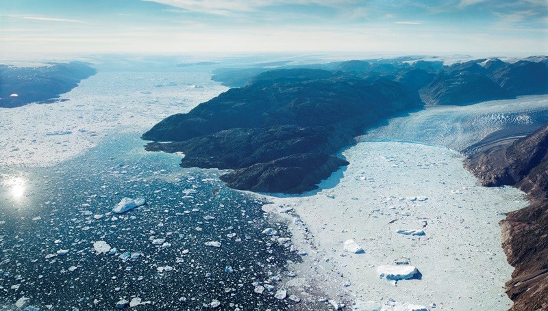
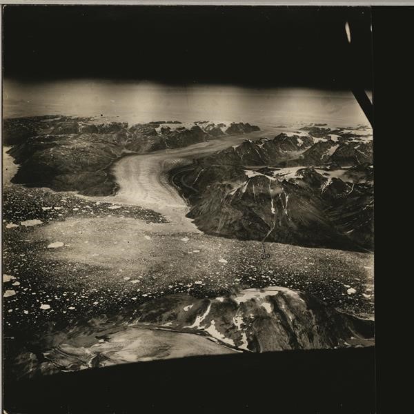
Helheim and Fenris Glaciers, Greenland – Klaus Thymann (2012) and Keld Milthers (1933)
In the early 20th Century, Denmark was in dispute with Norway over the sovereignty of eastern Greenland. To substantiate its claim, Denmark set forth expeditions to survey the remote region, including an aerial photograph survey by Danish explorer Keld Milthers in 1933. The aerial photographs, which were eventually rediscovered by Kurt Kjær of the Natural History Museum of Denmark in 2009, clearly outlined Greenland’s coasts, as well as the continent’s glaciers.
Collaborating with Kjær and the archive, Klaus Thymann revisited Helheim and Fenris Glaciers in East Greenland in 2012 to replicate the aerial photographs. The new photographs were taken same time of year as did Keld Milthers so that the historic and modern photographs can be compared directly. They demonstrate how the glaciers have retreated over 70 years.
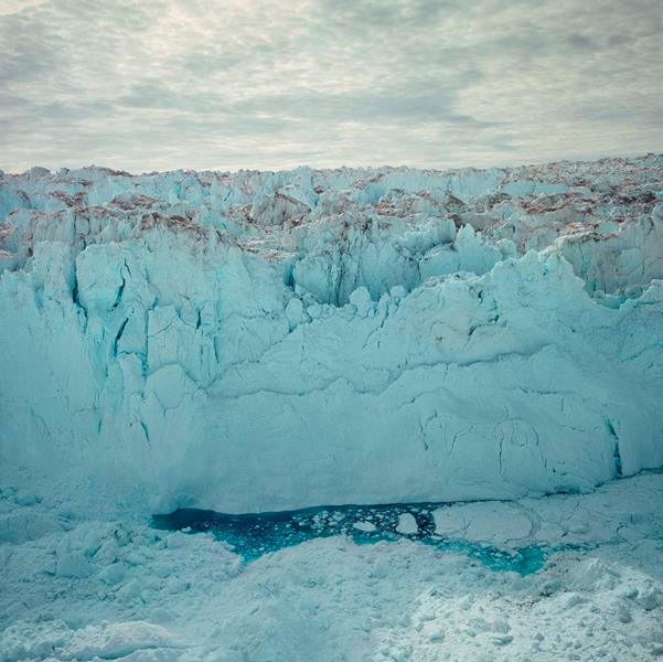
Jakobshavn Glacier, Greenland – Klaus Thymann (2009)
Shot out of an open door on a hovering helicopter, the image shows the front of the Jakobshavn Glacier in Greenland. The wall is about 70 metres high. This glacier is among, if not the most, active in the world, producing some 10% of all of Greenland’s icebergs. The glacier moves forward at an average pace of 20 metres per day.
Africa
Resembling those in South America, glaciers in Africa are altitude related. Occurring in high mountains and close to the equator, they are very sensitive to temperature changes and therefore to global warming. Some believe that Africa is likely to be the first continent to be glacier-free due to climate change.
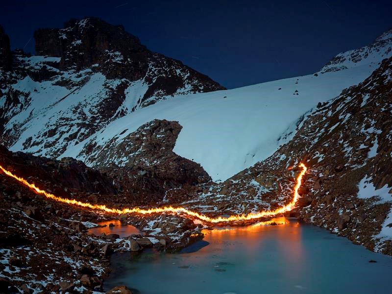
Lewis Glacier, Kenya – Simon Norfolk (2014)
Mount Kenya used to host many glaciers, this is no longer so. As a visual way of showing glacier retreat, Simon Norfolk used a self-made fire torch and a long exposure to demarcate the line to which a glacier once extended.
Mount Kenya is an extinct 5,199-metre volcano and this series intends to photographically re-awaken the mountain’s magma heart. The ‘Fire versus Ice’ metaphor is poignant owing to the trail of light being made from petroleum; the only evidence in these images that this glacier’s retreat is believed to be due to man-made climate change.
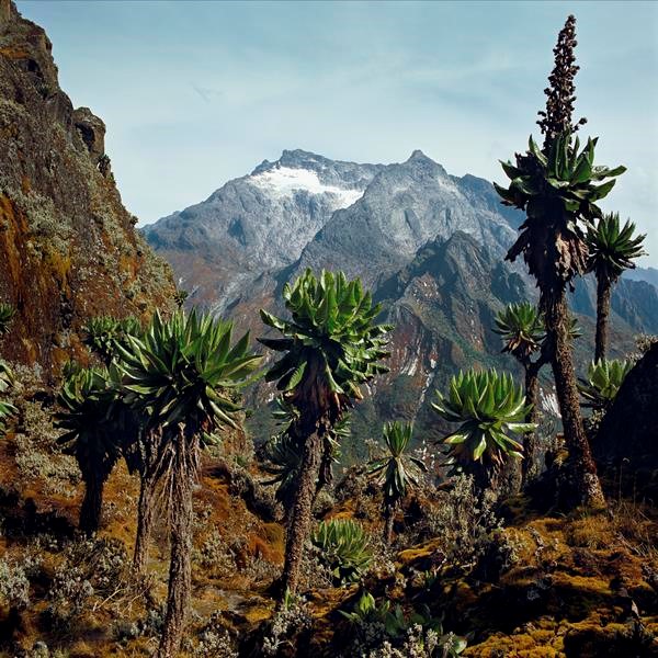
Speke Glacier, Uganda – Klaus Thymann (2012)
On the border of Uganda and the Democratic Republic of Congo, are the Rwenzori Mountains. This UNESCO-listed national park is home to six peaks above 4,600 metres, as the highest source of the Nile, they are also known as ‘The Mountains of the Moon’. Barely explored until the turn of the 20th Century it is estimated the glaciers will completely disappear within the next 15 years.
In 1906, there were 43 glaciers in the region; now only half remain and with a total coverage area of less than one square kilometre. The mountains are also home to 177 species of bird and mammals and an abundance of unusual flora. The tropical rains, high altitude and untouched landscape create conditions that encourages unique species to thrive. Thymann used a route that had lain unused for decades, after Congolese insurgents closed the park; through this route he discovered glaciers that were thought disappeared.
Australasia
No glacier exists in Australia. By contrast, there are as many as 3,000 glaciers in New Zealand. Many of them are located in the Southern Alps on the South Island and classified as mid-latitude mountain glaciers. They have been retreating since 1890.
When the glaciers retreat, some form proglacial lakes such the one shown in front of Donne Glacier, Mount Tutoko, New Zealand. Satellite imagery has revealed that many proglacial lakes in New Zealand are expanding in size due to glacier retreat.
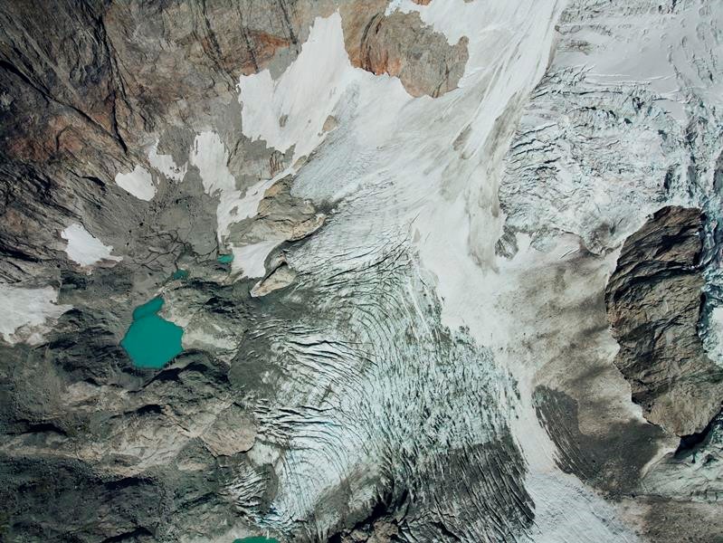
Donne Glacier, New Zealand – Klaus Thymann (2013)
Top view of Donne Glacier, which descends down on the east face of Mount Tutoka, southwest New Zealand. This glacier has been undergoing rapid retreat for decades and in 2000 a new unnamed alpine lake was formed.
Antarctica

Pine Island Glacier and Antarctic Peninsula, western Antarctica – Satellite Image (2016)
This image shows the Antarctic Peninsula in western Antarctica, with the Pine Island Glacier in the lower left.
The Pine Island Glacier, one the largest glaciers in western Antarctica, is the fastest thinning glacier in Antarctica, responsible for some 25% of Antarctica’s ice loss. It loses an extraordinary 45 billion tonnes of ice to the ocean each year — equivalent to 1 millimetre of global sea level rise every eight years. The ice loss rate is alarmingly accelerating. The single glacier contains about 52 centimetres of potential global sea level rise and is thought to be in the process of unstable retreat.
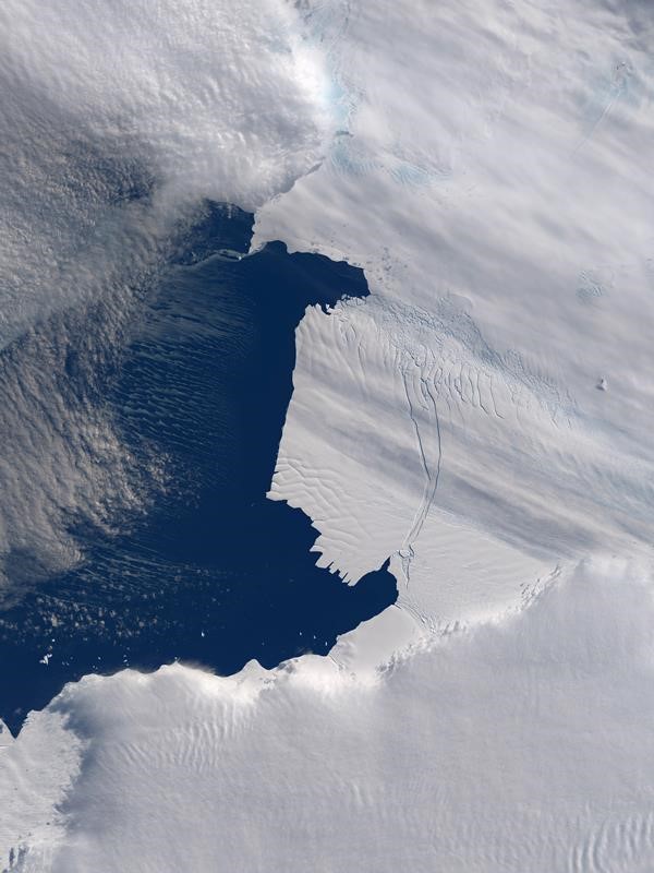
Larsen C, western Antarctica – Satellite Image (2013)
In July 2017, a giant iceberg, known as A68 and measuring 5,800 square kilometres in size, broke free from Larsen C ice field in western Antarctica. (For comparison, Hong Kong Island is 80.5 square kilometres in size) It is one of the largest icebergs ever recorded. This image is a retrospect of how Larsen C looked like in 2013 — a large rift had already been developed (centre of image).


